Skip to content
Arctic Circle
Published

Tracking Nighttime Lights to Evaluate Arctic Development Policies

By Paul Minard & Mathieu Landriault

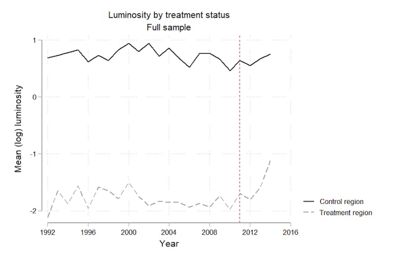
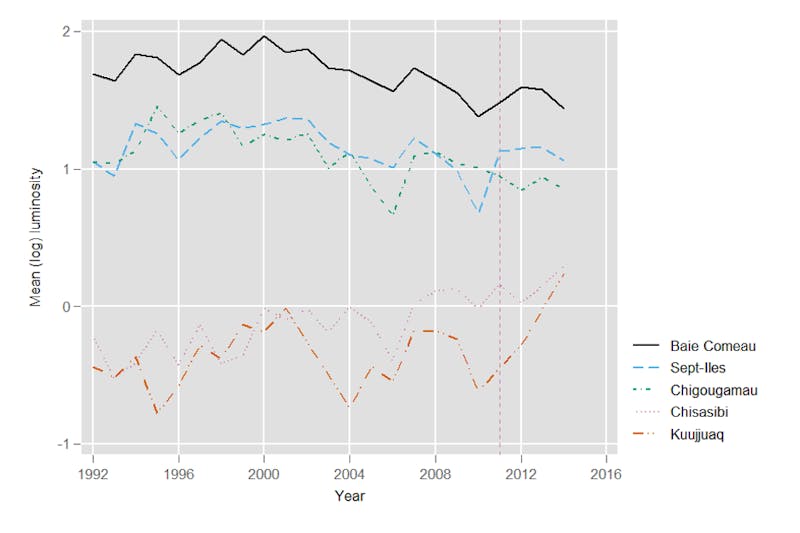
Arctic economic development has long been plagued with systemic problems, including lack of quality infrastructure, overreliance on the exploitation of natural resources with price fluctuations and high prices for basic necessities (including food and housing). Governments with territory north of the 60th parallel have deployed strategies and policies to address these problems. However, we still lack the tools to clearly assess the efficiency and effects of these billion-dollar investments.

Reliable impact assessments of place-based development policies, in particular in small, remote communities, require robust, timely, geographically precise data collected at regular intervals. Given challenges and limitations of traditional government statistics, a data source that would enable the evaluation of the long-term impacts of place-based economic development policies in an Arctic context would have several characteristics:

  1. Collected at regular, short-spaced intervals;
  2. Released in a timely fashion;
  3. Be geographically precise;
  4. Be mergeable with other geographically defined data;
  5. Can be aggregated to any configuration desired by researchers;
  6. Be available retrospectively, so that the decision to evaluate impacts need not be taken in advance of policy implementation;
  7. Be inexpensive.

We argue that using nighttime lights data recorded by satellites possess these characteristics.

Each night, satellites operated by the National Oceanic and Atmospheric Association (NOAA) orbit the Earth, recording images of cloud cover. Though originally intended to improve weather forecasting, the satellites also record nighttime lights emissions. Data are available at the resolution of a “pixel” (about 1km2 at the equator), and each observation is accorded a digital number representing luminosity on a 0-63 scale, higher values indicating greater luminosity. Annual and monthly data based on the Visible Infrared Imaging Radiometer Suite (VIIRS) instrument, carried by the Suomi National Polar Partnership (SNPP) are freely available, the latter with about a three-month delay.

The relevance of night lights data is manifold but one of its main functions is to track economic well-being. Multiple studies have shown that higher is correlated with higher GDP per capita, income, consumption and employment, to name just a few. We argue that this indicator is pivotal to assess the economic effects of major Arctic policies. Under project Arctic Lights, the Observatory on Politics and Security in the Arctic (OPSA) has begun applying this method to analyze the effects of specific political developments on economic wellbeing of Arctic communities, including Quebec’s Plan Nord.

Comparing luminosity levels north of the 49th parallel in Quebec from 1992 to 2015 with those below the 49th parallel, (below, the dashed line), we observe that positive economic effects were detected after the beginning of the plan in 2011 (indicated by the dashed line). Our back-of-the-envelope estimate is that the Plan is associated with a per capita income increase of roughly $750 CAD.

Nighttime lights data also offers the advantage of assessing place-specific development outcomes, allowing us to go beyond national indicators to evaluate policy effectiveness.

In the case of Plan Nord, for instance, we might ask if communities just North of the 49th parallel (Chibougamau or Baie-Comeau, for example) captured most of the benefits of the Plan, relative to communities located in the Quebec High North, such as Kuujjuaq (58th parallel).

Our analysis of nighttime lights data indicates that the benefits of Plan Nord increased as one moves to higher latitudes: luminosity increased more significantly the more we studied communities in Quebec’s high north. Kuujjuaq, the administrative center of Nunavik, substantially benefited from the Plan when compared with communities located in more Southern locations.

This method can be used similarly to conduct policy evaluations in Northern locales, whether such policies be a Northern strategy enacted by a national government, natural resource extraction projects or enhanced autonomy granted to local or regional administrations. Of particular interest to Arctic researchers and stakeholders, the high geographic resolution of the data allows to pinpoint Northern development and to focus on remote communities that are difficult to access.

To conclude, these findings are just the beginning of a broader project. The ultimate objective is to provide empirical evidence to facilitate policy evaluation in the Arctic region. We welcome fellow researchers, governments, businesses or civil society actors interested to contribute to this endeavour by communicating with Paul Minard (pminard@cegep-heritage.qc.ca), Mathieu Landriault (mathieu.landriault@enap.ca) or by consulting OPSA’ s website at https://cirricq.org/act/research-project-arctic-lights-and-arctic-economic-development/.

No. 15/2021, 17 November 2021

This article is a part of the Arctic Circle Journal Series which provides insight, understanding and new information. The material represents the opinions of the author but not those of Arctic Circle.

Paul Minard

Paul Minard is on the faculty of the Social Science Program at Cegep Heritage College and a researcher at the Observatory on politics and security in the Arctic (OPSA).

Mathieu Landriault

Mathieu Landriault is an adjunct professor at the École nationale d’administration publique in Gatineau and the director of OPSA.